On the first weekend of May 2017 I’m going to have a second attempt at becoming the first person to circumnavigate the M25 motorway non-stop, on foot. The walk will be approximately 160 miles and I hope to complete it in under 48 hours without sitting down at any time between when I start and when I finish.
I’m doing the walk to raise money for Limbless Association, a London based charity that provide support to people who have lost one or more limbs, and the people who care for them.
I consider myself very lucky to be able to walk the distances that I do. I have two good legs and two good arms, but not everyone does, which is why I have chosen to support Limbless Association in 2017.
In March 2016 I attempted to walk non-stop around the M25 motorway when I raised money for Sport Relief, and whilst I managed to complete the walk, I didn’t do it non-stop. You can read about last year’s walk here, but as a quick summary, I started at 2pm on the afternoon of Friday 11th March and went well until it good dark. Overnight the temperature fell and I suffered in the cold. By Saturday night I couldn’t face another night walking in the cold and after 32 hours I sat down (lay down) for the first time, and at 34 ½ hours I had had enough and I quit. I had completed just over 120 miles at that stage. On Monday morning I decided I was fully recovered and went back to where I had stopped, resumed walking, and finished at 7am on Tuesday morning.
This year I’m making a few changes that will hopefully ensure that I can achieve my goal.
Firstly, I will be starting at 8am on Friday 5th May which means that I can get a full day (50+ miles) before nightfall. Doing the walk in May hopefully also means warmer weather, but nothing is guaranteed when it comes to English weather!
Secondly, I’m going to walk anti-clockwise. You might not think that will make a difference which way I walk, but it means that by the time I get to Saturday afternoon/night, I’ll be walking through countryside that is more familiar to me. I’ve done a reasonable amount of walking and cycling on the southern side of the M25 and mentally, it will make a big difference walking in an area I know rather than somewhere I have never been before when I am struggling through the last 50 or 60 miles.
Lastly, I have mapped out a new route which is 99% on roads that I have been able to check via Google Maps street view. Last year I mapped out the course using Google maps but a lot of the time I found myself walking on muddy trails and down narrow alleyways that my support crew couldn’t drive down. There are only two small parts that are on trails and I will walk them at some stage between now and May to ensure that I know the route in advance. I’m also going to rely on an electronic map on my phone more this year than I did last year (when I had printed maps that I couldn’t see clearly due to tiredness), which will hopefully prevent me getting lost too much. Last year the walk ended up being 177 miles when I had mapped it as 165 miles – I got lost more than a few times. This year’s route should be 160 miles.
As with last year I have support from Fitbit, who will be providing a Fitbit Charge HR or Charge 2 (you can choose from one of the Fitbit’s shown below) as a prize to someone who makes a donation. To enter the prize draw simply make a donation via my Just Giving page. To increase your chances of winning, make a donation AND share at least one of my promotional posts on facebook or twitter, so please keep an eye out for these.
Make a donation and go in the draw to win one of these Fitbits.
Please click the ‘just giving’ link below to make a donation. Limbless Association will appreciate even the smallest donation.
Lastly, if you’ve got nothing better to do on the first weekend of May, and would like to be a part of my support crew for a part or all of the walk, please let me know. All help will be greatly appreciated.
Update:
On the Thursday before Easter Joel Clark, Funding & Communications Officer for Limbless Association interviewed me about the walk. Given that the walk is all about walking around the M25 motorway, we decided what better place to do the interview than the M25 itself!
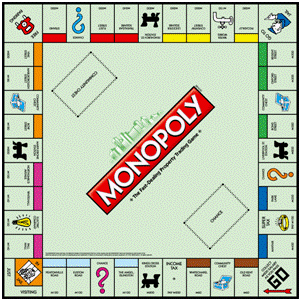
As a kid my cousins and I used to spend hours and hours playing Monopoly on the floor at our grandparents place. Every school holidays we would spend a sizable junk of our day buying and selling properties, building them up with houses and hotels to increase the rent that we would receive when someone landed on our properties, passing GO, going to Jail without passing GO, being wiped out when we had to pay property taxes, and occasionally landing on free parking.
We lived in New Zealand, 12,000 miles away from London (and the streets of the monopoly board), on the other side of the world. I don’t think we knew (or even cared) that the streets and railway stations, of the game we loved so much, were real.
We could recite the order that each property appeared in on the board without looking, and we knew the cost of each property, the rental that had to be paid on each property if it was an empty lot, had one, two, three or four houses, or a hotel. We were obsessed with the game.
Having moved to London several years ago, and walked many of the streets of London during my various walking adventures, I had visited many of the streets on the monopoly board and two of the four railway stations. Always on the lookout for another adventure, I decided to walk from Old Kent Road to Mayfair via every property and every railway station on the board – and in the order that they appeared on the board. I wasn’t going to worry about the Chance and Community Chest cards, nor would I visit the two utilities – Electric Company and Water Works. The Monopoly game was originally created in the US in the early 1900’s and it wasn’t until the 1930’s that the UK edition was created, and therefore the Electric Company and Water Works didn’t actually relate to any particular location – they were just places on the monopoly board. Nor did Jail or ‘Go To Jail’, reflect actual physical places, but I decided that I would visit HMP Pentonville as the Jail because it was near Pentonville Road, the property immediately before the Jail on the monopoly board, and I thought I would visit New Scotland Yard when I got to the ‘Go To Jail’ corner of the monopoly board. Also, I intended to find ‘Free Parking’ somewhere in between Vine Street and Strand – something that wouldn’t normally be easy to do in London, but I was going to do the walk on a Sunday which made it a little easier to find a parking space that I didn’t need to pay for 🙂
Walking the Monopoly Board:
I had estimated that the walk would take me something between 8 and 10 hours to complete and even although I was doing it on a Sunday, I wanted to start early so that I would complete most of the walk before the city became too crowded with pedestrians.
So I drove my car across South London and parked it in the car park in Burgess Park, just off Old Kent Road and then walked down to where I could find an ‘Old Kent Road’ street sign to take a photo of, before officially starting my walk from outside number 279 Old Kent Road at 5:45am.
Old Kent Road
My plan was to visit each property and railways station on the board, in order, and take a few photos – one of the street sign, and one or two of the street itself. These are the photos of Old Kent Road at 5:45am immediately before starting my walk.
About to start my adventure. Standing outside number 279, Old Kent RoadOld Kent Road at 5:45am
Whitechapel Road
Old Kent Road is the only property on the monopoly board that is south of the Thames, so the first leg of my walk was to head north and over the Thames via Tower Bridge, and up to Whitechapel Road.
Whitechapel RoadWhitechapel Road looking back towards the city
Kings Cross Station
Next was the long journey north west to Kings Cross Station. By the time I got here I had already been walking for 1 ¼ hours and was only half way along the first side of the monopoly board.
Kings Cross Station
Kings Cross Station is immediately next to St Pancras Station and the two stations are commonly referred to as ‘Kings Cross St Pancras’. St Pancras Station looks much more interesting than Kings Cross so I thought I would take a photo of that station too:
St Pancras Station (from outside the entrance to Kings Cross)
The Angel, Islington
Unlike the other properties on the monopoly board, The Angel, Islington isn’t a street but is a property on the corner of Islington High Street and Pentonville Road (according to Wikipedia) but when I arrived there I decided to take a few photos of different places in the area. These are the best of them:
Angel Station, Islington High Street
The Angel, Islington
The Angel, Islington – me and my halo
Euston Road
Next, it was back down past Kings Cross Station to Euston Road.
Euston Road looking back towards St Pancras stationEuston Road
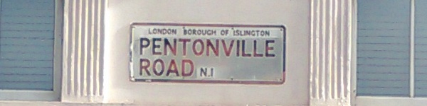
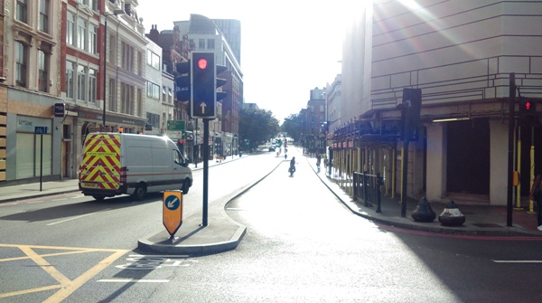
Pentonville Road
And back past Kings Cross again to Pentonville Road
Pentonville Road – looking towards Kings Cross StationPentonville Road
JAIL
There are nine prisons currently active in London – Belmarsh, Brixton, Feltham, Holloway, Isis, Pentonville, Thameside, Wandsworth, and Wormwood Scrubs (according to Wikipedia). There are also another 22 inactive prisons in the London area, some of which would have been operational back when the UK edition of Monopoly was created. I decided to visit HMP Pentonville as that wasn’t too far from Pentonville Road.
I had reached the end of the first side of the monopoly board in 2 ½ hours.
Pall Mall
Kings Cross to Pentonville Prison via all the ‘light blue properties’ (The Angel, Islington, Euston Road and Pentonville Road) only took me 1 ¼ hours, but it was now another long walk through to Pall Mall via Regents Park (and I got a little lost along the way) but I eventually arrived at the first of the ‘pink properties’ 3 ¾ hours after leaving Old Kent Road.
Pall MallPall Mall
Whitehall
Whitehall
Northumberland Avenue
Northumberland Avenue
When you play monopoly you could be forgiven for thinking that each property is close to the next one and that the railway stations are in the same area as the properties that are located on the respective side of the board, but this is not the case.
It was a 30 minute walk from Northumberland Avenue north west to Marylebone Station:
Marylebone Station
Marylebone Station
And then an hour south east to Bow Street, and the first of the ‘orange properties’:
Bow Street
As a kid playing monopoly I remember working out that if you could own all the pink and orange properties, and put hotels on them, you could win the game. This was because you could own a whole side of the board for a reasonable price, and because there were six properties on that side of the board (versus five on the first side) you had a 20% better chance that your opponents would land on at least one of your properties each lap of the board. And because the properties weren’t too expensive to buy, or to put houses and hotels on, compared to the red, yellow, green and blue properties, with some luck, you could get a monopoly over that whole side of the board much faster than you could elsewhere. It’s a pity I didn’t manage to carry this strategy through to real life. If I had, I would have much more time for these walking adventures rather than having to work during the week 🙂
Bow Street
Marlborough Street
In the 80+ years since the UK edition of Monopoly was created London has changed a little and there is no longer a Marlborough Street. There is a Great Marlborough Street and a Marlborough Road, and I decided that I would visit Marlborough Road as it seemed to me to be more within the ‘area’ of the pink and orange properties than Great Marlborough Street which is located towards the ‘green streets’.
Marlborough RoadMarlborough Road
Vine Street
Vine Street was actually a bit of a let down. It is the most expensive of the ‘orange properties’ on the monopoly board but in reality it is a short dead end road.
Vine Street
Free Parking
Next I had to find some free parking, but there wasn’t anywhere to park in Vine Street at all!
It was time to head west through the theater district to Strand and somewhere along the way I came across both of these parking signs:
Free Parking (on a Sunday)Not Free Parking!
Strand
It was now 12:30pm and I had been walking for 6 ¾ hours already and was only just arriving at the first ‘red property’. My original estimate of 8 to 10 hours was looking doubtful.
StrandStrandThe Royal Courts of Justice, the Strand
Fleet Street
Fleet StreetFleet Street
After Strand I walked further east to Fleet Street. Continuing in this direction would take me to Fenchurch Station but before visiting the next railway I had to backtrack to visit Trafalgar Square. I’ve never been keen on walking back the way I have already walked so I decided that I would walk a block or two south to the Thames and then walk along Embankment towards Northumberland Avenue and then up to Trafalgar Square. This would have been a good idea in theory, but somehow I managed to get lost inside the private grounds of the expensive residential properties between Fleet Street and Embankment and it took a bit of wandering around to find an unlocked gate to get out of the grounds again.
After leaving Trafalgar Square at 1pm it took me another 45 minutes to walk back past Strand and Fleet Street and up to Fenchurch Station:
Fenchurch Station
Leicester Square
And then another 45 minutes back to Leicester Square, which is only a few hundred meters north of Trafalgar Square!
And when I reached Leicester Square, which I had already walked through earlier in the morning enroute to other properties, I found that there wasn’t any room to walk due to a red carpet premier. The whole area was packed with people waiting to see some celebrities so I took a couple photos and then walked down a side street to get around the crowds to and on to Coventry Street (which actually runs off Leicester Square).
Leicester SquareLeicester Square
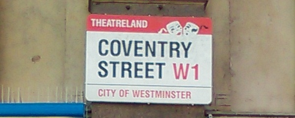
Coventry Street
Coventry StreetCoventry Street
Piccadilly
Coventry Street runs in to the last of the ‘yellow properties’, Piccadilly.
PiccadillyPiccadilly
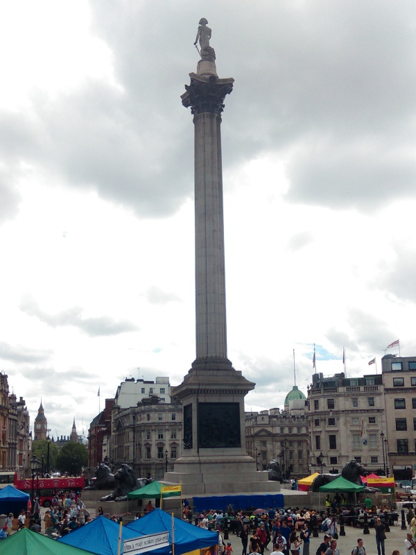
Go To Jail
It was now 2:45pm and I had been walking for 9 hours when things suddenly went wrong! I almost ended up in Jail after running in to this policemen at New Scotland Yard:
Go To Jail – Do not Pass Go – Do not collect £200New Scotland Yard
But fortunately I had one of these:
And was able to continue my walk to the first of the ‘green properties’.
Regent Street
Regent StreetRegent Street – closed to traffic on Sundays during July
Oxford Street
Oxford StreetOxford Street
Bond Street
Another change to the London map during the last 80+ years appears to be that Bond Street no longer exists and has been replaced with ‘New Bond Street’, but there is a Bond Street Station so I decided to visit that:
Bond Street Station
Liverpool Street Station
After leaving the last of the ‘green properties’ it was another long walk east to Liverpool Street Station. It was getting hot and I wasn’t walking fast, which meant it took over an hour to get there, and another 1 ¼ hours to get back to Park Lane.
Liverpool Street Station
Park Lane
I was now in to the most expensive area of the monopoly board – where landing on Park Lane with a hotel on it would set you back £1,500, and £2,000 for Mayfair. Land on Park Lane and then throw a double 1 and your game could be over!
Park LaneThe Dorchester, Park LaneA collection of luxury cars parked in front of The Dorchester, Park Lane – among otehr cars there is a Ferrari, a Bentley, and a Lamborgini parked here.
Mayfair
On the monopoly board, Mayfair is an area, not a street. I decided I would finish my walk at Mayfair Place, but before that I wanted to visit the centre of Mayfair – the Mayfair Post Office:
MayfairMayfair PlaceFinished!
The walk ended up being a total distance of 54 miles (87km) and had taken me 12 ½ hours. Not a fast pace, but I had stopped at 28 properties or stations along the way to take photos, as well as a couple other stops for food and water. I actually felt surprisingly good, which was just as well, as I still had to walk another 4 miles back to Old Kent Road and Burgess Park where I had left the car !
Monopoly walk map – not a simple walk around a square board
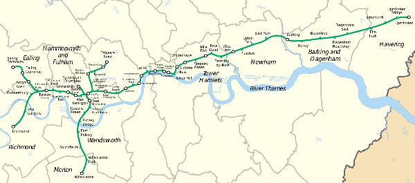
As someone who commutes in to London on the District Line on a regular basis, travelling a large portion of the trip underground and only surfacing when I arrive at my destination, I have often wondered what the various tube stations we pass look like from the outside.
The District Line is one of 11 tube lines that make up the London Underground network and in total it comprises of 40 miles of track with five main start/end points – Richmond and Ealing Broadway to the west, Edgeware Road to the north, Upminster at the eastern end, and Wimbledon to the south – and a total of 60 stations where passengers get on and off the tube, change to other tube lines, the overland rail service, or the DLR (Docklands Light Railway).
What the District Line map really looks like. Photo credit: Wikipedia
When I decided that I wanted to walk the District Line I used Google Maps to map out a route that would take me from Richmond (near where I live) through London and out to Upminster, and then from Wimbledon to Edgeware Road, and from Turnham Green to Ealing Broadway (the western part of the District Line branches off at Turnham Green and goes to both Richmond and Ealing Broadway). I also thought I would add in a quick out and back section between Earl’s Court and Kensington Olympia (1 mile each way) to cover the section of the District Line that only runs when events are on at the Olympia convention center.
In total this measured 48 miles along roads that would enable me to visit all 60 stations, and as I was going to be celebrating my 48th birthday soon I thought what better day to do this walk than on my birthday.
Leg 1 – Richmond to Upminster
At 3:30am on the morning of Thursday 14th July I was standing outside Richmond Station ready to head off on my adventure. The station was locked as the first tube doesn’t depart running until 5:30am on weekdays, and there wasn’t anyone to be seen anywhere. I took a couple photos including one showing the clock on the front of the station building and set off on my walk.
Richmond Station at 3:30am
The start of the first leg took me from Richmond to Kew Gardens and was reasonably straight forward as I have walked all around the Richmond and Kew area over the last few years.
Kew Gardens Station
On arrival at the Kew Gardens station there wasn’t anyone there either, although there were a few bikes chained up outside. I took another couple photos and headed off towards Gunnersbury.
In preparation for the walk I had printed off my google maps (6 double sided pages in total) but when I went to check the route I realised that even with the help of the street lights, my eyesight wasn’t good enough to read the small printed maps. So out came my trustee cell phone and I typed ‘Gunnersbury tube station’ in to the Google Maps app.
Gunnersbury was the first of the many stations on the District Line that I had never seen from street level. The tube from Richmond to Hammersmith is all at ground level, but I had never got on or off the tube at Gunnersbury and didn’t really know exactly where it was.
It wasn’t long before I arrived at Gunnersbury though – I had only been walking about 40 minutes in total. I took a couple more photos, and kept moving.
Gunnersbury Station main entranceThe platforms at Gunnersbury Station
It was at this stage when I realised that this was going to be a much slower walk than I had expected. Firstly I was walking slower than my normal training pace but this was probably just because it was dark and I often walk slower in the dark than in daylight, but I had also realised that stopping at each station to take photos was taking somewhere between 30 and 60 seconds each time. Multiply that across 60 stations and my total walk was likely to take as much as an hour longer than budgeted. Not a major issue though. Today was all about having an adventure and spending time on my feet. I wasn’t too concerned about my overall pace.
After Gunnersbury I headed for Turnham Green. The Google maps app guided me and I arrived just before 4:30am. This is the first station where there were actually people to be seen – only one person, and he was unlocking the security gate. I have been to Turnham Green a few times so knew what it looked like but I somehow it looked a bit different in the semi-dark. I took my photos and moved on.
Turnham Green Station
Next was Stamford Brook, about 1 kilometer away. Another station that I had never seen from ‘outside’ – which is partially why I ended up going down an alleyway to back entrance before managing to find the front of the station.
Stamford Brook Station
The stations were closer together now as we were getting closer to London, and it wasn’t much further along the route until I arrived at Ravenscourt Park – another station that I had never seen from the outside.
Ravenscourt Park Station
Another kilometre and I was at Hammersmith. Although it was only 5am, it was now daylight. Hammersmith actually comprises of two separate stations. On one side of the road is the station that is the end of the Circle and Hammersmith & City tube lines (I’ll be walking those lines at a later date so didn’t take any photos of that station), and on the other side of the road is a massive round-about that is the main Hammersmith underground and bus station. The District Line passes through this station as does the Piccadilly Line which I often change on to at Hammersmith when travelling in to central London. On the route from Richmond, Hammersmith is the first station where passengers can change tube line and as a result it is always much busier than other stations I had passed on my journey. I don’t know if it is related, but in the 500 meters leading up to Hammersmith I also came across the first of the many homeless people I would see during the next hour or so sleeping in doorways.
Hammersmith Station – District and Piccadilly Lines
The next station, Barons Court, was another kilometre down the road. This was the eighth station (including Richmond) that I had passed so far, and the fourth that I hadn’t previously seen the outside of.
Barons Court Underground Station
On the tube itself, by now we are underground and I hadn’t previously seen the next four stations either.
First was West Kensington Station
West Kensington Station
Followed by Earl’s Court – the junction between the District Line running from Wimbledon to Edgeware Road and the District Line between Richmond/Ealing Broadway and Upminister.
Earls Court Station
Most stations have multiple entrances and my walk was only going to take me past one side each station, but I would see the other side of Earls Court this afternoon when I walk from Wimbledon towards Edgeware Road.
After Earls Court it was a little over another kilometre until I reached the Gloucester Road station.
Gloucester Road Station
And then South Kensington
South Kensington Station
And then a relatively ‘long’ stretch of about 2km through to Sloane Square
Sloane Square Station
Followed by the next big station, Victoria. As well as being a junction of tube lines, Victoria is also a major railway station for both the London overland trains as well as national trains and buses. I walked a lap of the Victoria station looking for the best photo opportunity but unfortunately the main part of the station was hidden behind scaffolding.
Victoria Station refurbishment sign
Victoria Station
Victoria Station
St James Park station came next
St James Park Station
And then I arrived at Westminster underground station, and the River Thames. I was only 13 miles (21km) in to my walk and it was already after 6:30am. I was 30 minutes behind my planned pace.
Westminster StationBig Ben
I took a ‘selfie’ in front of Big Ben (which is across the road from Westminsiter station) and then headed off along the Thames embankment, passing Embankment
Embankment Station
And then Temple
Temple Station
enroute to Blackfriars. Blackfriars Station is another junction for both the underground and overland rail, and also has the unique feature of rail platforms over the River Thames.
Blackfriars Station
After Blackfriars came Mansion House – the 20th station of my adventure. Based on the name, I had always assumed that the Mansion House station would be an impressive sight, but it was completely the opposite. Whilst it does have a street entrance (apparently), I couldn’t find it. All I found was several subway entrances – stairs down to the underground.
Mansion House underground station
The next station however, was one of the larger tube stations in the city as it also doubles as a railway station. Cannon Street station is just a few hundred meters from Mansion House and after that it is just another few hundred meters to Monument station – which again, only appeared to consist of subway stairwells.
Cannon Street StationMonument Station
And then I reached the last station on the District Line that I am familiar with; Tower Hill. Tower Hill station is across the road from the Tower of London and near Tower Bridge, but it isn’t on a hill so I don’t know where that name comes from.
Tower Hill Station
After Tower Hill I headed away from the Thames passing Aldgate East station as the commuter traffic was starting to pick up.
Aldgate East Station
About a kilometre further on I arrived at Whitechapel as the market traders were setting up down the road.
Whitechapel Station
And then Stepney Green a few hundred meters further along the road.
Stepney Green Station
It was only another kilometre up the road to Mile End station which is the only station east of Tower Hill that I had been to previously.
Mile End Station
And another few hundred meters long the road I reached the Bow Road station.
Bow Road Station
Bromley-By-Bow station was next. As I arrived at Bromley-By-Bow my cellphone battery died meaning no photo. But because I wanted a photo of every station, and I was working in Tower Hill the following day, I made a quick trip on the tube at lunchtime to take this photo.
Bromley-By-Bow Station
From Kew Garden station through to now I had been relying on Google Maps on my cellphone for navigation except when all the stations were on the same road such as along Embankment and the road from Aldgate East through to Bow Road stations. I had printed some Google maps before leaving home but my map reading skills aren’t the best and this proved to be the case when I got totally lost in between Bromley-By-Bow and West Ham stations. Eventually I got back on track though and found the 30th station, West Ham. And I also charged my phone using one of the three USB charging sticks I was carrying with me.
West Ham StationPlaistow Station
The stations were a little more spread out now but it was still less than a mile between stations, with the next station on my journey being Plaistow followed by Upton Park.
Upton Park Station
And East Ham followed by Barking.
East Ham StationBarking Station
Upney (the 35th station of my walk) was next and then Beacontree.
Upney StationBeacontree Station
And then the two Dagenham stations; Dagenham Heathway
Dagenham Heathway Station
And Dagenham East
Dagenham East Station
After Dagenham East it was a 4km walk through to Elm Park. I think this was the only stretch (other than when I got lost between Bromley-By-Bow and West Ham) when I had to walk along way from the track. I had to walk a big L shaped course as there were no direct roads and to ensure I didn’t get lost I started using Google Maps on my phone again.
Elm Park Station
After Elm Park came Hornchurch
Hornchurch Station
Followed by Upminster Bridge
Upminster Bridge Station
And then finally I arrived at Upminster after 38 miles (61km) of walking and 8 ½ hours after leaving Richmond Station. The 42nd station that I had visited so far.
Upminster StationThis is what I look like after 8 1/2 hours of walking!
And that was only the end of the first leg of my adventure!
I was now well behind schedule. I had estimated (measured via Google maps on my computer) that the Richmond to Upminster leg would be about 32 miles and expected it to take no more than 7 hours. I had also hoped to leave Richmond at 3am and not 3:30am. My plan of walking the whole district line in one day was looking doubtful as I was supposed to be going out for dinner and a movie to celebrate my birthday in a more traditional style (than walking 48 miles because I was turning 48) and needed to be home no later than about 6pm. It was now 12 noon and I still had over 16 miles plus a few train journeys to go.
I jumped on the tube that was about to leave for what I thought would be a 1 hour trip to Wimbledon via Earls Court. And 1 ½ hours later I arrived at Wimbledon ready to start the second leg.
Leg 2 – Wimbledon to Edgeware Road
Wimbledon Station
I’ve caught the tube in to London from Wimbledon a few times but other than a couple stations I hadn’t seen the outside of most of the stations between Wimbledon and Edgeware road 10 miles away.
Having just completed an 8 ½ hour walk followed by 1 ½ hours sitting on a tube I expected my leg muscles to be a little tight as I started walking but I was surprised to find that I felt OK. If anything, the only discomfort I was feeling was the small toes on both feet which felt a little bruised in my shoes. I was wearing Injini toe socks and had covered my feet in 2Toms Anti-Blister Powder before I left home, so I wasn’t expecting any problems, and so far, so good.
The first station on my journey north was Wimbledon Park one mile away.
Wimbledon Park Station
Southfields Station was next
Southfields Station
Followed by East Putney
East Putney Station
And then I crossed the Thames via the rail bridge to arrive at the Putney Bridge station.
From Putney Bridge through to the finish at Edgeware Road there was never more than a kilometre between stations.
Putney Bridge Station
Parsons Green Station
The next station was Parsons Green followed by Fulham Broadway.
Fulham Broadway Station
And then I came across possibly the most interesting part of my walk when I walked through the Brompton Cemetery on my way to the West Brompton station. I have walked through quite a few London cemeteries over the last two years but the Brompton Cemetery was something else. As well as plenty of graves from the 18th and 19th centuries, there were lots of large family tombs. These were often the size of small garden sheds. Something I hadn’t noticed in other cemeteries. I could have taken plenty of photos, but I didn’t take any. Instead I walked through the cemetery and around the corner to the West Brompton station – the 50th station that I had visited today.
West Brompton Station
The next station on my route was Earl’s Court which I had visited earlier in the morning. This time I approached the station from the south so got to see another entrance to the station.
Earls Court Station
About 500 meters north from Earls Court I arrived at the next station – High Street Kensington
High Street Kensington Station
Followed by Notting Hill Gate. I’m not sure if there is a street level entrance to the Notting Hill station. All I found was this:
Notting Hill Gate Station
Bayswater station was next but I almost missed that as my Google Maps app diverted me down a side street around the back of the station. Once I realised my mistake I back tracked to ensure that I walked past the station entrance and got another photo.
Bayswater Station
And then I headed for Paddington. Strangely, this is one of my favourite stations but not because of the station itself. It is just a short walk along the canal from the finish of the Grand Union Canal Race which is probably my favourite race out of all the ultra-distance races I have ever done.
Paddington Station
And less than a kilometre later I completed the second leg of my walk when I arrived at Edgware Road – the 56th station I had visited today.
Edgeware Road StationLeg 2 of my District Line walk completed!
It was now 4:30 in the afternoon and there was no way I would be able to complete either of the last two legs of the District Line and get home in time to go out for dinner. I decided to delay the final two legs, which were only going to be 1 mile and 3 miles respectively, until Saturday and caught the tube back to Richmond via Earls Court.
Richmond Station – a bit busier than it was 15 hours ago!
Leg 3 – Earls Court to Kensington Olympia
I decided to combine the final two legs in to a 20 mile walk on Saturday morning that also incorporated the Fulham Palace parkrun. I parked the car beside the river in Putney where you can park for free all day on Saturdays and after completing the parkrun (5km) I walked up to Earls Court station to start the third leg of my journey.
Earls Court Station – the start of leg 3 of my District Line walk
This was by far the shortest leg at less than one mile. The District Line only runs to Kensington Olympia when there are events on and today there was a ‘50+ exhibition’. Being only 48 I decided not to visit the exhibition and walked the 2 ½ miles through to Turnham Green in a direct line, rather than following the tube line, ready to begin the fourth and final leg of my adventure.
Kensington Olympia Station from the eastern sideLooking across the platforms towards Kensington Olympia exhibition centreKensington Olympia station – western side
Leg 4 – Turnham Green to Ealing Broadway
The final leg took me along a part of the District Line that I had never traveled before. The first station, Chiswick Park, was exactly 1 kilometre from Turnham Green.
Turnham Green Station in daylight (it was dark when I was here last time)Chiswick Station
Next was Acton Town followed by Ealing Common
Acton Town StationEaling Common Station
And only 3 miles after leaving Turnham Green I arrived at the final station of my adventure – Ealing Broadway.
Ealing Broadway Station – the end of my District Line walk
In total I had walked 53 miles (not counting the extra mileage on Saturday before Earls Court and between Kensington Olympia and Turnham Green) and visited all 60 stations on the District Line. Possibly the first person ever to do this on foot!
It wasn’t a fast walk by any means. I had stopped at every station to take a photo or two – 150 photos in total – but the walk wasn’t about speed. I had had a great adventure and found myself already planning my next adventure* as I walked back to the car in Putney.
 In March 2016 I attempted to walk non-stop around the M25 motorway when I raised money for Sport Relief, and whilst I managed to complete the walk, I didn’t do it non-stop. You can read about last year’s walk here, but as a quick summary, I started at 2pm on the afternoon of Friday 11th March and went well until it good dark. Overnight the temperature fell and I suffered in the cold. By Saturday night I couldn’t face another night walking in the cold and after 32 hours I sat down (lay down) for the first time, and at 34 ½ hours I had had enough and I quit. I had completed just over 120 miles at that stage. On Monday morning I decided I was fully recovered and went back to where I had stopped, resumed walking, and finished at 7am on Tuesday morning.